Masters of Maps: Piri Reis and Mercator
Photographs by Aydın Ramazanoğlu
The historical period often called the "Age of Discovery," when navigators set off on sea voyages to explore the far corners of the world, was also a golden age of cartography. The years 2012 and 2013 mark the 500th anniversaries of two milestones in the history of mapmaking: the birth of cartographer Gerardus Mercator in Rupelmonde, Belgium, in 1512, and the production by Ottoman cartographer Piri Reis of a world map in 1513.
In conjunction with these anniversaries, and also coinciding with the October 15-20 visit of a Belgian economic mission to Turkey under the auspices of Prince Philippe of Belgium, Bilkent University hosted an exhibition and symposium on these giants of 16th-century cartography.
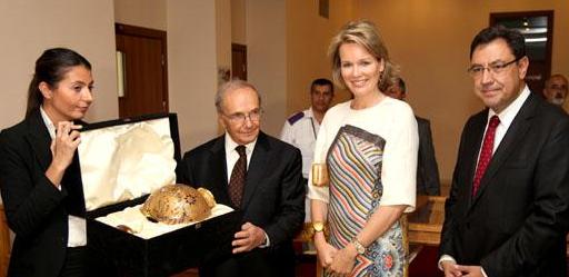
The exhibition "Master of Maps: Piri Reis and Mercator" opened on Thursday, October 18. The opening ceremony, which was attended by Princess Mathilde of Belgium, began with welcoming remarks by Prof. Metin Heper, vice rector and provost of the university. Dr. Mehmet Kalpaklı, acting chair of the Department of History, and Giselle Marien, president of the Turkish-Belgian Friendship Association, also spoke during the ceremony. The event included an opening tour of the exhibit for Princess Mathilde.
The associated symposium was held on October 19 in Mithat Çoruh Auditorium, where an expert group of international scholars and historians talked about the two cartographers, their historical impact and their continuing influence over the centuries. The event served both as a celebration of Mercator's 500th birthday, and as an introduction to UNESCO's Piri Reis Anniversary Year in 2013.
The day-long symposium opened with a welcoming speech by Prof. Dilek Önkal, dean of the Faculty of Economics, Administrative and Social Sciences, and the sessions were moderated by members of the Bilkent Department of History. Preceding the sessions, eminent Ottoman historian and department member Prof. Halil İnalcık offered introductory remarks. Prof.
İnalcık began by pointing out that the Ottoman Empire was also a maritime empire. He also proposed that Kâtip Çelebi should not go without recognition in the proceedings, as it was Kâtip Çelebi who ordered Mercator's "Atlas Minor" to be translated for Ottoman use.
Moderated by Dr. Paul Latimer, the morning session focused on Gerardus Mercator (1512-1594). The famous Flemish cartographer, cosmographer and mathematician was the first to use the term atlas to designate a collection of maps and during his lifetime was responsible for the production of innumerable maps, globes, charts and astronomical and navigational tools.
Speaking first, Dr. Thomas Horst (University of Munich), who has published extensively on Mercator, cartography and cosmography, focused his presentation on the life and work of Mercator. He also spoke about the globes commissioned from Mercator by the Ottoman Sultan Murad III (1579), which were sold in London in 1991 to anonymous buyers. Were they available to scholars, their further study could illuminate issues such as the relations between East and West at the time.
Maritime historian Dr. Jan Parmentier (curator at Antwerp's Museum Aan de Stroon) discussed in detail how the seas were navigated in the 16th and early 17th centuries, with particular attention to the actual maps, charts and astronomical and navigational tools developed by scientists and used on ships. He also made reference to paintings of navigators and geographers/ cosmographers from this period, which give some idea of the way in which men such as Mercator were perceived at the time.
As a professor of geography and an expert on geographical information systems, Prof. Philippe De Maeyer (University of Ghent) offered yet another perspective, concentrating on the Mercator projections. Prof. De Maeyer noted that the influence of Mercator's cosmographical and cartographical work has never entirely ceased: Mercator projections remain a standard in mapmaking today. This is particularly so in maritime navigation, he said, but we also use them unknowingly when referring to Google and Bing maps.
The symposium's afternoon session, moderated by Dr. Evgeni Radushev, focused on Piri Reis. The Ottoman admiral, navigator and cartographer is known for his "Kitab-ı Bahriye" (Book of Navigation) and his first world map of 1513.
Entitled "Piri Reis and Ottoman Nautical Charting in the Sixteenth and Seventeenth Centuries," the talk by Dr. Dimitris Loupis presented the history of cartography and cosmography in that period's Ottoman Empire. He argued that one may speak of a long tradition of map- and nautical chart making, in which the work of Piri Reis signifies an important point. Dr. Bülent Arı, director of Dolmabahçe Palace - and, like Dr. Loupis, a former student of the Department of History at Bilkent -- spoke primarily about "Kitab-ı Bahriye," Piri Reis's major work. Having already edited a recent publication of this work, Dr. Arı is now in the process of preparing a new edition. His talk considered the difficulties involved in the project and made a special case concerning the need for a scientific, critical edition of the work, possible only if experts from diverse disciplines unite to undertake the task.
 The last presentation, by Dr. İbrahim Yılmaz (Afyon Kocatepe University), an engineer in cartography, discussed the extent of the scientific information derivable from Piri Reis's maps.
After a discussion period, the proceedings ended with a short closing ceremony. The apparent success of the symposium gave rise to serious talk among the participants about repeating the event at other locations around the world.
Alp Rodoplu (HIST VI) & Fatih Pamuk (HIST VI)